
With existing buildings, one of the problems shows up right at the start: not everyone is always working from the same information.
The architect may receive an old plan. The structural engineer needs different dimensions. The MEP designer finds that a beam sits lower than the drawing shows. On site, openings have moved, walls have changed, and there are level differences that were never in the original documentation.
Sometimes the changes are known. Sometimes they were made years ago and the drawings they were built from no longer exist.
This is where 3D laser scanning helps.
We measure the building as it is at that moment and use the same data for the measured survey, sections, elevations, the 3D model or BIM. That way, every discipline on the project can start from the same existing condition.
What we actually measure
The laser scanner records the surfaces it can see from each scan position.
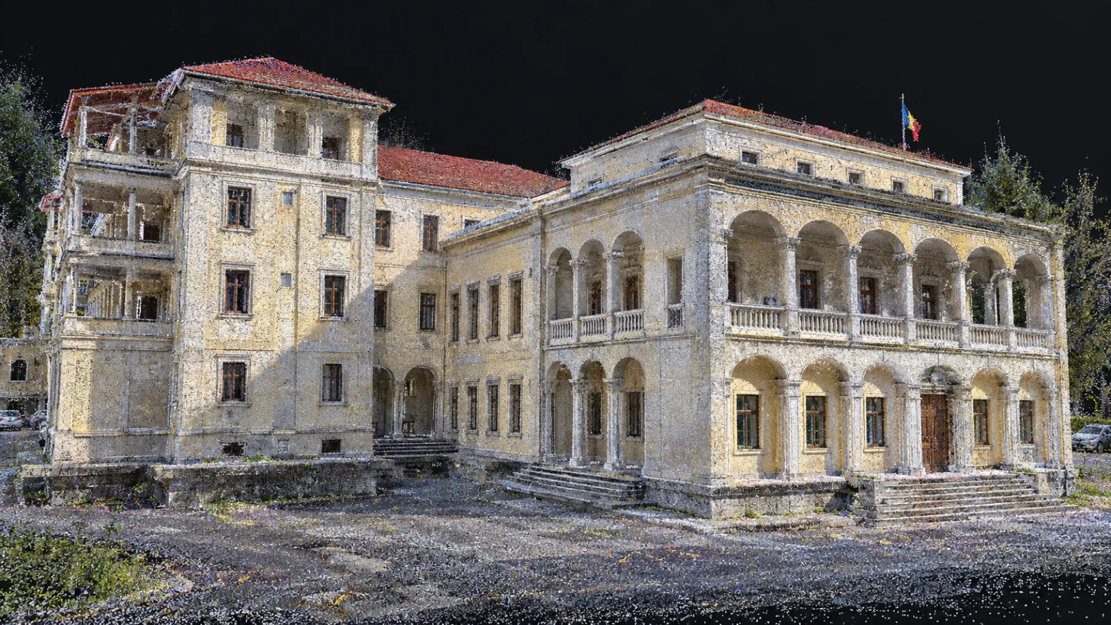
The result is the point cloud.
In a building, depending on access and the scope of work, this can include walls, openings, columns, beams, ceilings, floors, stairs, façades, roofs and the services that are exposed.
It does not mean the scanner sees through walls, or that we automatically learn what is inside a beam.
But the geometry that can be seen and measured stays in the point cloud and can be checked later.
From this data we then produce what the project needs: plans, sections, elevations, orthophotos, 3D models or BIM models.
Why old drawings need to be checked
Existing drawings are useful. We ask for them before going on site whenever they are available.
But we need to see whether they still match the building.
Over time, partitions change, openings are closed or created, fit-outs are done, services are modified. There are also differences between the design and what was actually built.
Older buildings also show geometric deformation. Walls are not always plumb, floor levels can differ, and two elements that look identical on a plan can have different dimensions on site.
That is why a cadastral plan or an old architectural plan should not automatically be treated as a measured survey for design.
They were made for other purposes.
What the architect uses
For the architect, the advantage is simple: design can start on the geometry of the building as it stands today.
They get the real position of walls and openings, the level differences, the shape of the façades, the circulation and how the rooms relate to each other.
On a regular building this may look like a detail.
On a building with several wings, successive interventions or complex façades, the differences start to matter.
We do not try to make the building look “straighter” in the drawing than it is in reality. The survey has to stay faithful enough to the measured condition for what the architect is going to design.
What the structural engineer can take from the same data
The structural engineer has different questions.
They are interested in the position of visible structural elements, how they relate to each other, level differences, and certain deformations or geometric deviations.
This is where the point cloud can be very useful.
Sections can be cut through the critical areas, and some dimensions can be checked later without sending the team back to site straight away, as long as that area was captured well enough.
But measurement and structural assessment are different things.
3D scanning does not tell you whether a structure is safe.
It does not measure concrete strength, it does not automatically find hidden reinforcement and it does not establish the cause of a crack.
That is the job of the structural expert, opening-up works, investigations and specific testing.
We give them the geometry to work on.
MEP has the same problem
On refurbishment or change-of-use projects, services quickly run into the reality on site.
A route drawn correctly can end up in a beam that was not on the plan.
A ceiling can be lower than expected.
An existing pipe can occupy exactly the space where a new route was supposed to go.
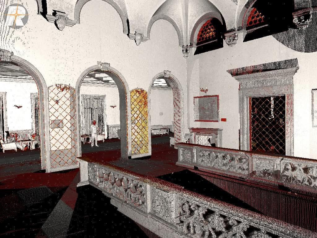
If the existing services are exposed at the time of scanning, they can appear in the point cloud and be used for coordination.
What is hidden in ceilings, walls or floors has to be checked by other methods.
We do not pretend the scanner can measure what it cannot see.
One base can serve several disciplines
This is one of the most useful parts of the process.
There is no need for the architect, the structural engineer and the MEP designer to each start from a different set of measurements.
They can use the same point cloud and the same base drawings.
One will need extra sections. Another a model. Another may work directly in the point cloud for certain checks.
The scope is agreed before the work starts, because not every project needs the same level of detail.
On one project a 2D survey may be enough.
On another, a full BIM model makes sense.
An example: a medical building of approximately 14,000 m²
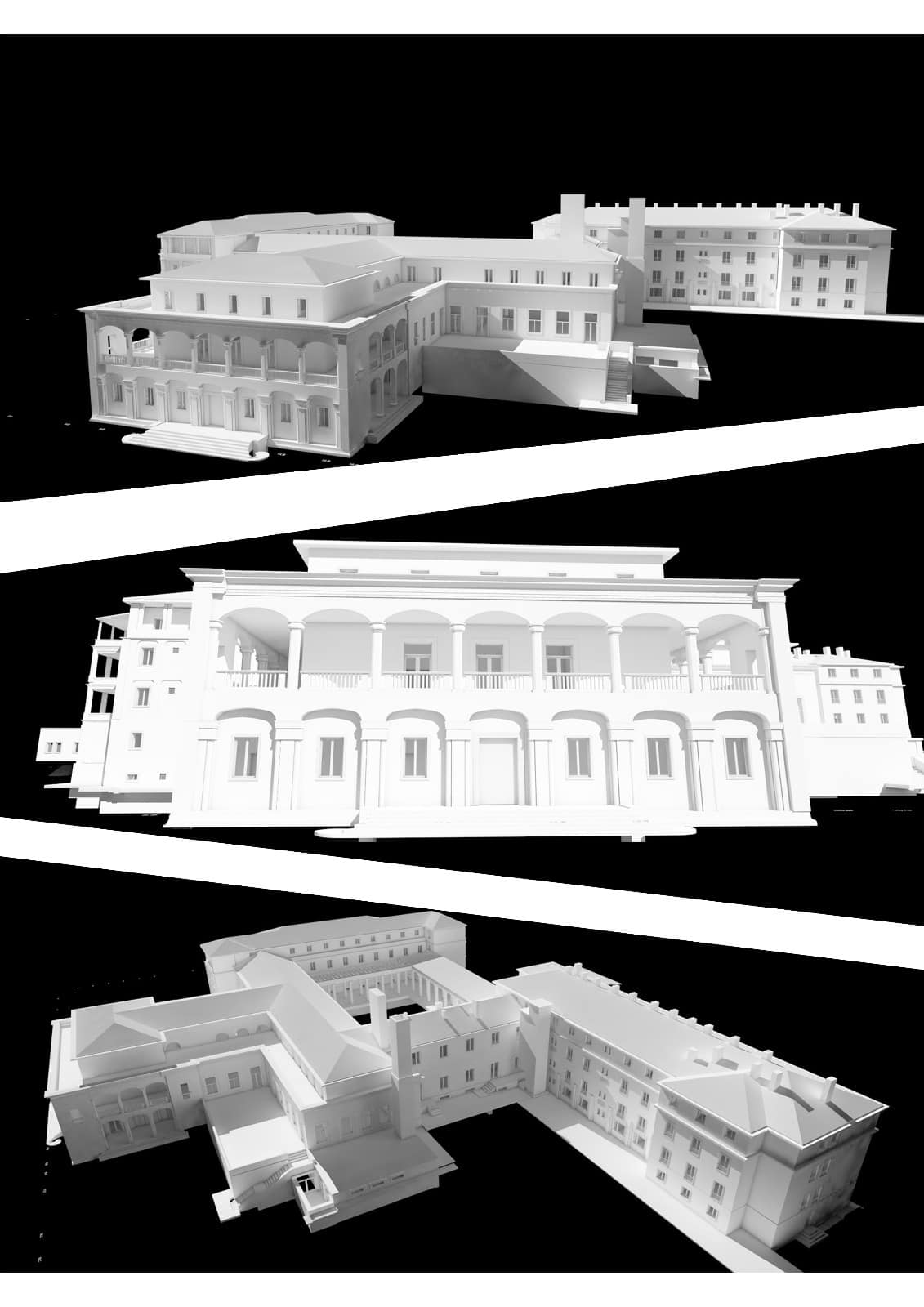
At the Elias Section in Băile Olănești we had to document an existing medical building of approximately 14,000 m².
We scanned the interior and the exterior, then registered and checked the data.
Modelling and drafting were done on the point cloud.
On a building of this size it is no longer about taking a few dimensions.
Levels, wings, circulation, façades and interior spaces all have to be tied together. If each part were measured independently, the differences would add up very quickly.
The point cloud gave us the common reference from which we could build the documentation for design.
On monuments and historic buildings the differences are even more visible
Here, regular geometry is the exception rather than the rule.
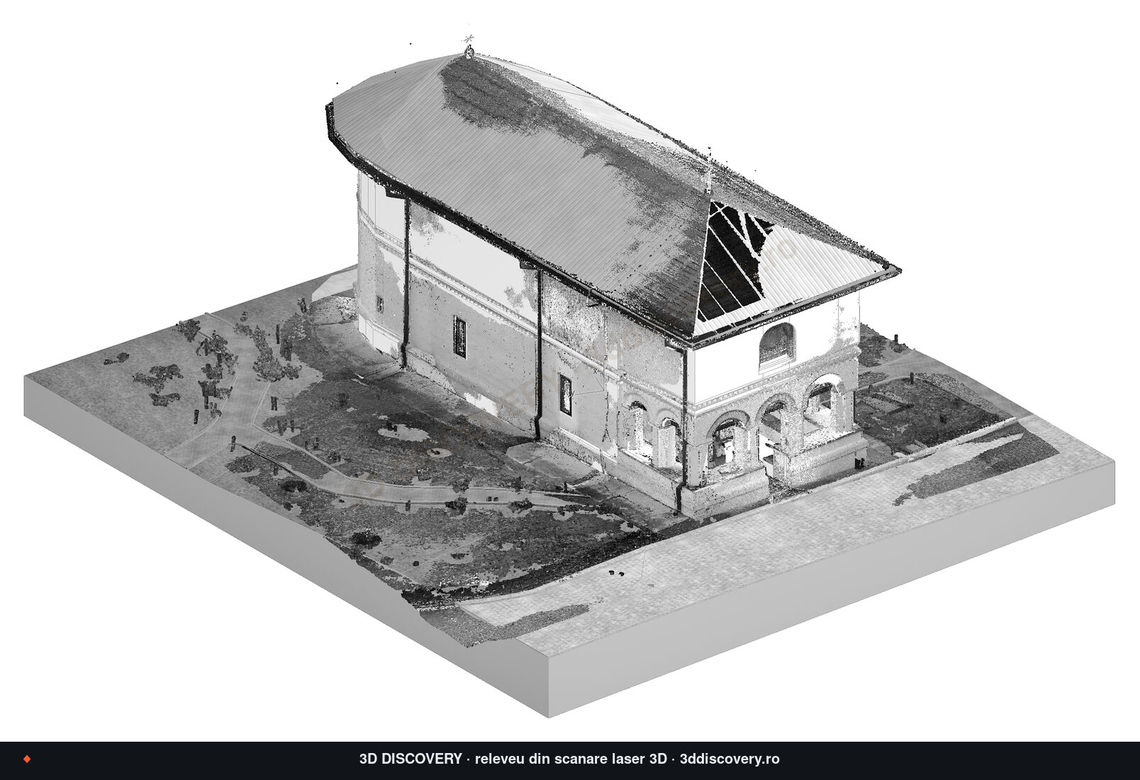
We see walls out of plumb, vaults that differ from one another, irregular openings, level differences and façades with many profiles or decorative elements.
In these cases we use scanning as the base for heritage surveys: plans, sections, elevations, orthophotos and, if the project requires it, HBIM.
The conservation architect and the certified specialists, however, determine the materials, the decay, its causes and the intervention.
Our model does not replace that part.
It gives them measured geometry to work on.
The data can stay useful during construction
The point cloud does not have to be archived as soon as the drawings are done.
Questions come up during design.
A dimension that did not seem important at first becomes important a few months later. A section is needed in another area. The position of an opening or a beam has to be checked.
If the area was scanned well, many of these checks can be done directly in the data.
On some projects a follow-up scan can also be done during or after construction, for comparison or as-built documentation.
Not every building needs 3D scanning
This needs to be said clearly.
For a small, regular, easily accessible building, a conventional measured survey may be enough.
We use scanning mainly when the size, the geometry or the amount of information needed justifies the method: large buildings, several floors or wings, complex façades, many sections, interventions on old buildings, uncertain existing documentation, or projects where several disciplines work at the same time.
There is no point complicating a job just to use the scanner.
The method should be chosen based on what the designer needs to receive.
What 3D scanning does not solve
We have also met the expectation that a scan can answer almost any question about a building.
It does not work that way.
The scanner measures visible surfaces.
It does not see the reinforcement in concrete. It does not automatically see through plasterboard. It does not tell you what is under the finishes. It does not determine material strength and it does not establish whether a crack is active or what is causing it.
All of that requires the investigations set by the specialists.
Scanning solves the geometric part.
And it is good to know exactly where its role ends.
Frequently asked questions
Can 3D scanning be used for a structural assessment?
Yes, as geometric support.
The structural expert can use the point cloud, the plans and the sections, but the assessment is carried out and signed by the expert. Scanning does not replace it.
Can the architect and the structural engineer work on the same point cloud?
Yes.
In practice, this is one of the reasons the method is useful on complex projects. The team has the same geometric reference, even if each discipline uses different information from it.
Can BIM be produced from a scan?
Yes.
The point cloud is used as the reference for building the model of the existing condition.
At 3D Discovery we work mainly in Archicad and, depending on the project, can also deliver Revit, IFC or other formats agreed with the designer.
The level of modelling has to be agreed beforehand.
There is no point modelling every ornament or every imperfection if the project does not need them.
Can dimensions be taken after the survey is delivered?
Often, yes.
If the element is visible and was captured well enough during scanning, we can go back into the point cloud for extra dimensions or checks.
It is one of the advantages we see most often on projects involving existing buildings.
Want to see what the deliverables look like? Download a measured survey sample: plan, section and elevation as PDF, plus the ground floor plan as DXF.
Where we start
Before a quote, a few simple things help: the location, the approximate floor area, the existing drawings if available, and what the design team needs to receive.
From there we can decide whether the job needs 3D laser scanning, conventional survey or a combination of both.
We can also agree the deliverables: point cloud, plans, sections, elevations, orthophotos or a BIM model.
Our role stays the same: to document the existing condition well enough that the people who design and check the intervention can work from the same base.
48-hour check: what needs measuring before design
Answer three questions. Within 48 working hours of receiving your files, we tell you what geometric risks the building carries compared with the existing documents, and what needs to be measured. No obligation; the quote for documenting the existing condition comes after.
1. What documents do you have for the building?
2. What does the design team need to receive?
3. What stage is the project at?
Building location
Send on WhatsAppEmail your files
Send old drawings, permits or cadastral plans to office@3ddiscovery.ro (PDF, DWG, photos). First reply within 24 working hours.